-

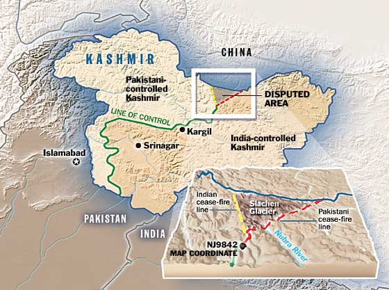
The roots of the conflict over Siachen lie in the non-demarcations on the western side of the map beyond a grid point known as NJ 9842. Hostilities between India and Pakistan over ownership of the Glacier date back to the first Indo-Pak war of 1948, over the territorial dispute of Jammu & Kashmir. A Cease-Fire Line (CFL) was established as a result of the 1949 Indo-Pak agreement that concluded the war in Jammu & Kashmir. The CFL ran along the international Indo-Pak border and then north and northeast until map grid-point NJ 9842, located near the Shyok River at the base of the Saltoro mountain range. Because no Indian or Pakistani troops were present in the geographically inhospitable northeastern areas beyond NJ 9842, the CFL was not delineated as far as the Chinese border. Both sides agreed, in vague language, that the CFL extends to the terminal point, NJ 9842, and "thence north to the Glaciers".
India's 'North' lies along the ridgeline North (yellow line) and Pakistan's 'North' goes North East (red line)!
 Posting Permissions
- You may not post new threads
- You may not post replies
- You may not post attachments
- You may not edit your posts
-
Forum Rules


Bookmarks